Kenmare ND - Features
Real People. Real Jobs. Real Adventures.

Thanks for reading some of the latest features about area people and events.
To view every page and read every word of The Kenmare News each week,
subscribe to our ONLINE EDITION!
Alliance drilling under Des Lacs Lake at Lakeshore crossing
Drilling operations for Alliance Pipeline’s Tioga Lateral Project along U.S. Highway 52 at the Lakeshore Crossing north of Kenmare slowed down last week after drilling mud bubbled up to the surface and spilled across the Upper Des Lacs Lake ice.
1/16/13 (Wed)
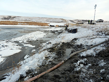
Drilling mud mess . . . Mud makes its way up from the ground
and onto the Des Lacs Lake ice north of U.S. 52 at Lakeshore
crossing as a result of surface releases, or "frac-outs", caused by
Alliance Pipeline drilling operations. The vacuum hose shown above
has removed the majority of the released material, which consists
primarily of water and bentonite clay. Cleanup operations for
the non-toxic spill are expected to continue through the spring.
Frac-out occurs during drilling
By Caroline Downs
Drilling operations for Alliance Pipeline’s Tioga Lateral Project along U.S. Highway 52 at the Lakeshore Crossing north of Kenmare slowed down last week after drilling mud bubbled up to the surface and spilled across the Upper Des Lacs Lake ice.
The surface releases occurred along the north side of the highway, on the Des Lacs National Wildlife Refuge. “I’m concerned, but it doesn’t appear to be a toxic spill,” said refuge manager Chad Zorn. “It’s just a mess.”
The releases are also known as “frac-outs” because the drilling mud makes its way to the surface through fractures in the rock and substrate being drilled. Pressure from the drilling activity pushes the mud through and along those fractures, until the mud breaks through the topsoil layer.
The first surface release occurred January 6th, with four other releases following that one last week. According to Rob Gray, senior communications advisor for Alliance Pipeline, the drilling action was taking place 80 feet below the surface at the time and has since been deepened to 110 feet to reduce the potential for more releases.
Alliance is using the horizontal directional drilling technique on this portion of the Tioga Lateral Project to cross underneath the Des Lacs Refuge and the lake. The process involves drilling the hole beneath the area, then pulling pipeline through that hole, according to Gray.
“This is commonly used to cross...environmentally sensitive areas,” he said. “The method was chosen so as to avoid digging a pipeline trench through Des Lacs.”
Drilling mud is pumped to the drilling head during the process. From there, the mud circulates through the hole to remove drill cuttings and maintain the integrity of the hole, according to Gray, unless it makes its way from the drill holes to the surface through fractures or weak places in the substrate.
The horizontal drilling section for the pipeline extends just over a mile along the U.S. Highway 52 right-of-way. Gray explained that four of the releases occurred along the right-of-way, while one surfaced on the west hillside above the lake. He described the releases along the right-of-way as concentrated in an area adjacent to a backwater separated from the main lake by a man-made peninsula.
Zorn said he was notified January 7th about the first release. He and Lostwood National Wildlife refuge manager Kory Richardson inspected the site and returned later in the week after other frac-outs took place.
“From what I understand, this drilling mud is mostly bentonite and water,” said Zorn. A drilling fluid additive known as MAX GEL is present in the material, with small amounts of gypsum and quartz and tridymite silicas, none of which are defined as hazardous in the safety data information.
Zorn said Alliance and Natural Resource Group personnel at the site estimated about 12,000 gallons of material were released, including about 4,200 pounds of MAX GEL. Gray estimated the rough volume of the release at 15 cubic yards.
“This material poses no risk to the environment and poses no health risks, when mixed with water, as was the case with this release,” said Gray.
Zorn said siltation fences were installed by Alliance around the released mud. “We’re working with them to establish a plan of action for the cleanup,” he said. “We need to get this off the ice and out of the vegetation down there. Cleanup could run into the spring.”
Alliance crews started cleanup operations last week, after stopping the drilling activity. Gray said the drilling mud still in liquid form outside of the containment areas was removed by a vacuum truck, while frozen drilling mud was removed with a track hoe and bucket. Any additional mud that enters the containment areas is now extracted with a vacuum truck.
“About 80 percent of the released material has been removed from the area,” he said. “The remaining 20 percent flowed onto ice in an area where it is not currently safe for workers to operate and will be removed as soon as conditions allow.”
As of Monday, Gray noted mud had stopped flowing from all five release sites and drilling operations had resumed, with plans to be completed within the month. The frac-outs caused a delay in the original schedule, which has also been extended by a slight change in the drilling procedure.
“The drilling process is slowed to reduce the potential for surface releases by advancing the drill head for a certain distance and then pulling it back to reduce the pressure in the hole,” Gray explained.
Zorn reported details of the incident to the U.S. Fish & Wildlife Service Ecological Services field office in Bismarck, while Gray said the U.S. Army Corps of Engineers and National Department of Transportation were both notified about the spill by Alliance. “Alliance Pipeline will ensure that the release is properly cleaned up and that the area is returned to normal condition,” he said.
Traffic was not stopped on U.S. 52 during the drilling or clean-up operations, although Gray acknowledged this type of project can add some traffic to the already-busy highway.
The drilling operations are taking place beneath the Des Lacs Lake as part of the larger construction project for the Tioga Lateral Project. When completed, the new pipeline will carry natural gas from a site near Tioga along the 79.3-mile route to Sherwood, where the gas can then be transported to market through an existing Alliance mainline.
Gray encouraged any area residents or stakeholders with more questions about the surface releases to contact Alliance Pipeline directly.
“They can do that through their land agent or by calling our toll-free telephone number at 1-855-667-9558,” he said. “We are committed to reviewing and responding to all concerns.”
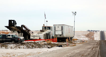
The drill starts here . . . Horizontal directional drilling operations
are taking place now along U.S. Highway 52 at the Lakeshore
crossing north of Kenmare. A hole is being drilled about 110 feet
below the surface to accommodate a mile-long segment of pipeline
for the Alliance Pipeline Tioga Lateral Project.