
Thanks for reading some of the latest features about area people and events.
To view every page and read every word of The Kenmare News each week,
subscribe to our ONLINE EDITION!
Mouse roars out of Canada
Just as the National Weather Service predicted, water keeps roaring down the Mouse River out of Canada, and for the first time since flood control structures were built there in the early 1990s, a voluntary evacuation of Mouse River Park has been ordered.
4/20/11 (Wed)
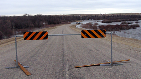
Access denied . . . A barricade at the west entrance into Mouse
River Park prohibits drivers from venturing into the flood waters below.
The diversion channel at the Park has been overflowing the spillway
on the road since April 6th, but visitors can enter the Park through
the east entrance. A voluntary evacuation was ordered for
the Park on April 14th, with river levels expected to crest this weekend.
Evacuation ordered at Mouse River Park
By Caroline Downs
Just as the National Weather Service predicted, water keeps roaring down the Mouse River out of Canada, and for the first time since flood control structures were built there in the early 1990s, a voluntary evacuation of Mouse River Park has been ordered.
Jim Burbidge, president of the Renville County Water Resource Board, said an evacuation order was deemed necessary after Renville County Emergency Manager Kristi Titus called a meeting on Thursday. The discussion included Burbidge and fellow board member Roger Sauer, along with representatives from the County Commission, Park Board and Sheriff’s Department.
“Roger and I laid out the numbers for what was expected,” said Burbidge. “We’ve never seen water this high before.”
The elevation of the river at the stop logs in the Park was 1603’ by 2 pm on Friday, an elevation which held constant through Monday. The Water Resource Board considers the evacuation point for the Park to be 1601’.
Burbidge watches the readings at the Sherwood Gauge on the Mouse River. “Late Saturday night or early Sunday morning, they started inclining as the water from Boundary Reservoir started getting there,” he said. “Normally, within 24 to 48 hours, that water should be at the Park, but the cold weather these last few days has given us time to get the river flow down.”
In fact, by Monday the forecast for the Sherwood Gauge, which read 19’, had changed slightly. “Now, they’re saying it should reach 22 feet on April 23rd,” said Titus, “then go up to 22.5 feet, but it’s not such a steep, rapid increase as they had it before.”
Previous predictions called for an increase of five feet in the river level at Sherwood within a matter of a couple of days, but the new indications will allow more time for water to be released from the Lake Darling dam downstream of the Park.
As of Friday, the Rafferty and Alameda reservoirs on the Mouse River in southern Saskatchewan were both holding all their water, with releases from Long Creek through Boundary Reservoir now slowing down.
“All these things together in a progression are helping us,” Burbidge said.
Park conditions
According to Burbidge, the idea of the voluntary evacuation was to give Mouse River Park’s seasonal residents time to visit their cabins and move or remove items. “We expect the crest at Sherwood on Saturday night and Sunday, so we have a little bit of time for water to get to the Park,” he said.
The west entrance to the Park is blocked because of water going over the diversion channel spillway on the road at that point, and a barricade has been put in place. Water started flowing over the spillway there on April 6th. “Every time I go down there, it’s deeper and wider,” said Burbidge.
Titus cautioned visitors against driving or walking through the running water at the west entrance, even though that roadway is paved.
The east entrance to the Park is open, but Titus advised visitors to be careful. “Water is not running into the Park,” she said, “but the water table is so high that we’re seeing a lot of ground saturation. Much of the baseball diamond is underwater, and Coles Road is now underwater down by the baseball diamond.”
She continued, “We want people to be aware of where the water is. The roads are getting soft and muddy, and we do want people to be safe when they’re on the roads.”
At this point, the Park remains open, but Titus and Burbidge agreed they wanted to see reduced traffic in the area, allowing residents to use the water-logged roads rather than too many interested onlookers.
“We know we have a lot of people who enjoy our Park, but we want to make sure the residents can get down there,” Titus said. “We are concerned about that east entrance, and it might get to the point where we have to restrict access only to residents.”
Burbidge and Titus emphasized the flood control structures and dike are holding. “Water is not flowing through the park,” Titus said, “but we want people to understand that pumping might not compensate if water comes down and flows over the dike.”
Flood controls holding
Burbidge and Sauer have monitored the status of the dike and flood control gates at the Park on a daily basis. “We went down there again shortly after the meeting and Roger walked part of the dike,” said Burbidge. “For the most part, everything seemed to be pretty good.”
The pump continues to operate at the Park’s sluice gate on the south side, running at 2000 rpm. “We probably have enough leakage to let that pump run,” Burbidge said, adding that Farmers Union Oil Co. of Kenmare can deliver diesel fuel to the pump in one of their smaller trucks. “If we start seeing some erosion, though, we’ll shut that pump off and leave.”
Both flood control gates are operating correctly, with no damage. “We’ve worked on it a couple of times to make sure,” Burbidge said, “but we think the planks may seal better than they have been because of the pressure of the water.”
Burbidge noted members of the Army Corps of Engineers have been vigilant about conditions at Mouse River Park, too, making frequent visits to the site and walking the dike. “They’re really watching everything,” he said, “but it seems like everything is par per usual for now.”
Once the river levels reach their peak, Burbidge said residents can expect to see that high water for about four days. “It’ll gradually start working back then,” he said, “but if it snows or rains any measurable amount, we’re playing by new rules again.”
He and other members of the Water Resource Board expect to see damage to roads in the Park once the water recedes. “We’ll probably need some fill along the south edge of the spillway,” he said. “That’s been the case in the past when we’ve had less water.”
Log removal will be another task after the river drops, with a large pile of logs already collected from the box culverts at the Park’s west entrance as a result of water releases throughout the winter. “We’re going to have trees to haul away,” Burbidge said, then laughed. “Don’t be in a hurry to get your camper out and dash down to Mouse River Park this spring.”
Lake Darling
ramps up releases
Below Mouse River Park, the Lake Darling Dam has started increasing its releases again, going from 2900 cubic feet per second on Friday to 5000 cfs this week. “We want to ramp up specifically to match the targeted flow at the Minot northwest gauge,” said Kelly Hogan, project leader for the Souris River Basin National Wildlife Refuge Complex.
The releases will allow the lake to hold the higher flows predicted from Boundary Reservoir. “We’ll take the elevation of Lake Darling up to 1600.9 feet, so water will be high.”
All releases from Lake Darling are monitored through the dam’s sluice gates and Tainter gates. “We’re doing releases now to make sure this water is following behind water that came down the Des Lacs River,” Hogan said, “and in order to make room for what we know is coming.”
Hogan agreed with Burbidge that Mouse River Park visitors will see increased water levels through the next few weeks. “The river will be manageable,” he said, “but flows will be high. We’ll all be dealing with it.”
Ed Eaton, senior hydraulic engineer with the U.S. Army Corps of Engineers, offered reassurance to Park residents. “We’ve been looking at the dike and the lowest point near the pumping station, and there’s still about three and three-quarters to four feet of room left to the top of the levee,” he said. “We’re trying to delay more releases out of Canada as long as possible with the cooperation from the Canadian government.”
He continued, “In Renville County, you should be starting to see releases from Boundary [Reservoir] filter down here, but we do not anticipate a problem at Mouse River Park. The evacuation was not because of an imminent threat. In fact, in the old oxbow, the pump has been working well and the water level is down in there.”
According to Burbidge, the voluntary evacuation has gone well, with several of the Park’s residents taking advantage of the time given them to remove personal belongings and valuables from their cabins.
“We’ve had a lot of the curious down there over the weekend, too,” Burbidge said, “just to take a look. We should have had a coffee and hot chocolate stand for them!”
He also expressed gratitude to residents along the Mouse River in that part of the county. “We’ve been fortunate in that the people who live along the river are so good about sharing information,” he said. “That’s really appreciated.”
Anyone with further questions about conditions at Mouse River Park or the voluntary evacuation order can contact Renville County Emergency Manager Kristi Titus at 701-756-6288.